Downloads

The graphic representation of the Architectonic and Urbanistic Articulation of the Studies of Technical Economic and Environmental Pre-Viability for the Metropolitan Waterway Ring of São Paulo is presented in four series of products. The 000 Series features the loads circuit and passenger navigation. The 100 Series features the six excerpts of the Metropolitan Waterway Ring of São Paulo, the interferences and interventions. The 200 Series consists on the specific interventions along the waterway: transpositions (Locks) and Ports (terminals). Finally, the 300 Series presents a set of illustrative images.

TEXTS

Conceptual Report

The Conceptual Report, after a brief contextualization of the fluvial issue in São Paulo, presents concepts such as the multiple use of water, fluvial navigation, fluvial urban public loads transportation, reverse logistics, industrial ecology, loads circuit, urban fluvial ports and structuring elements of the fluvial city. Finally, are presented the steps for deploying Metropolitan Waterway Ring of São Paulo, and the prospects for expansion of the Alto Tietê waterway network from 2040.

Descriptive Memorial

The Descriptive Memorial shows the graphic production developed in the study (plans, sections and illustrations) from the concepts presented in the Conceptual Report. The book contains the description of the boards, divided into 000, 100, 200 and 300 series, according to the scale of representation. The appendices contain: list of the locks and ports in the Metropolitan Waterway Ring of São Paulo, with the appropriate codes and locations; construction schedule; tables with the areas of intervention by sector, the list of existing and proposed interventions in the canal.

NAVIGABILITY

GRAPHIC PRODUCTION

    000

    A-001: São Paulo Macro Metropolis

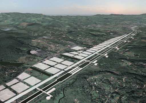
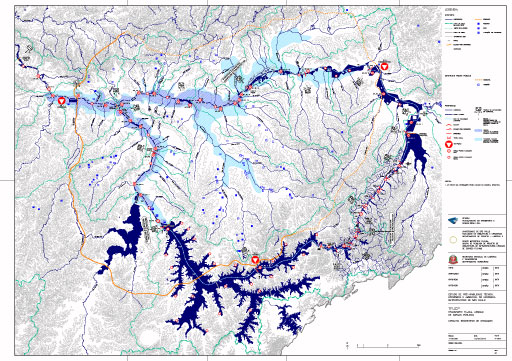
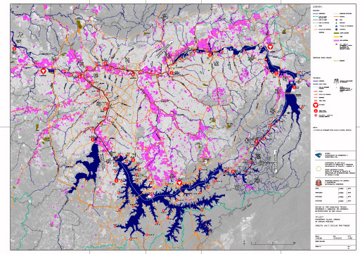
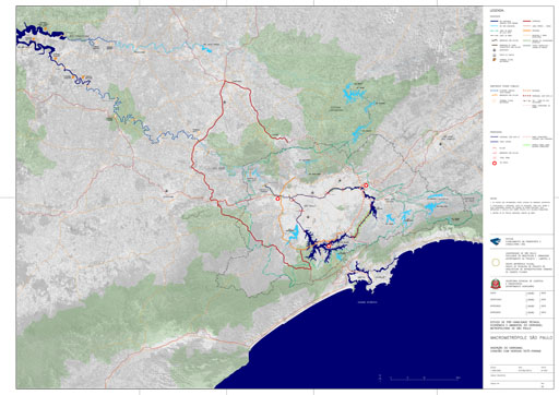
    São Paulo Macro Metropolis - Waterway ring of São Paulo insertion

    Waterway ring insertion in the Metropolitan area of São Paulo and the connection with the Waterway of Tietê-Paraná

    A-002: Alto Tietê basin

    Alto Tietê basin - Metropolis of São Paulo - Main axis and structural poles

    A-003A: TFU - Urban Fluvial Transport

    TFU - Urban Fluvial Transport – navigability

    In order to enable navigability in the Tietê River, Pinheiros River, Billings dam and Taiaçupeba dam, are necessary several civil engineering works, such as: canals, locks and dams. The lateral Billings-Taiaçupeba canal, which connects the Billings dam and Taiaçupeba dam, is a proposition of a vector for urbanization in which the water is the axis that structures the infrastructures, public equipments and dwellings.

    A-003B: TFU - Urban Fluvial Transport

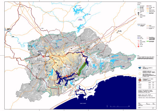
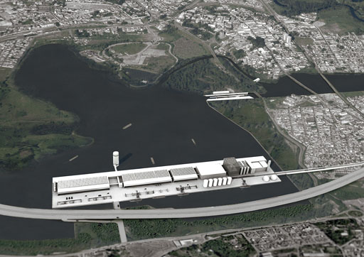
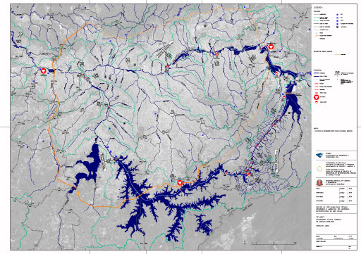
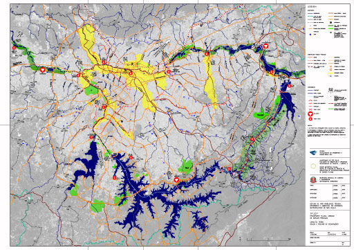
    Urban Fluvial Transport - navigability - Complementary Proposals: Small Metropolitan Waterway ring and Guarapiranga reservoir

    The small Metropolitan Waterway ring – a complementary proposition for the Metropolitan Waterway ring, is formed by Tamanduateí River, Riberão dos Meninos River, Ribeirão dos Couros River and Alvarenga-Couros artificial canal. Besides providing navigation, this proposition will contribute for the water level control in rainy periods. The other complementary proposition is the connection of the Guarapiranga dam with the Pinheiros River, through a lateral canall with dam.

    A-004: TFUCP - Urban Fluvial Transportation of Public Cargo

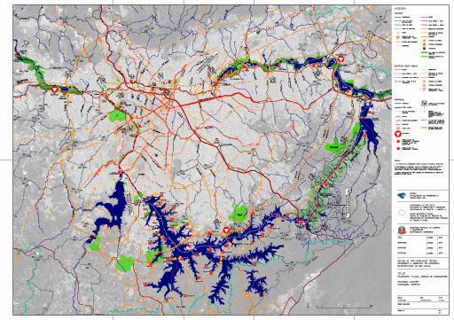
    Urban Fluvial Transportation of Public Cargo - Circuits: Dredging sediments

    The sediments that accumulate in the riverbeds, originated from the slit up process and the improper garbage disposal, need to be constantly removed from the waterway. In order to reach this ongoing maintenance, are proposed two types of floating dredgers. The fix port-dredgers keep berthed narrow to downstream from the mouth of the bigger rivers, providing maximum prevention of the sediments to arrive at the waterway. On the other hand, the float mobile dredger is a vessel that moves along the canal and cleans the mouth of the smaller affluent rivers and the bottom of the creek dams.

    A-005: TFUCP - Urban Fluvial Transportation of Public Cargo

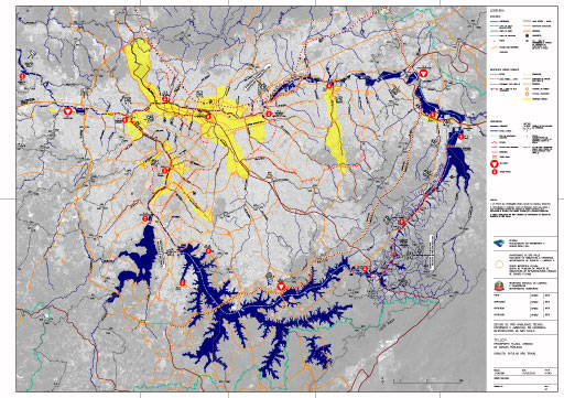
    Urban Fluvial Transportation of Public Cargo - Circuits: Mud

    The mud, waste originated from the process of the treatment of the water and sewage, needs to be deposited in a proper site. For such, it is proposed the implantation of mud-ports beside the sewage treatment stations (Estações de Tratamento de Esgoto – ETE) and the water treatment station (Estação de Tratamento de Água – ETA) - wich are in the waterway’s influence area. The mud will be transported from the mud-port to the tri-port through the urban cargo ship (Barco Urbano de Carga – BUC) – which is formed by double hulls and locked cargo.  In the tri-port the mud will be processed and will transform into blocks for paving.

    A-006: TFUCP - Urban Fluvial Transportation of Public Cargo

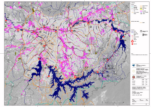
    TFUCP - Urban Fluvial Transportation of Public Cargo - Circuits: non-selected waste

    The term “waste”, used in this study, refers to the follow categories of solid wastes. Urban solid wastes, waste generated from domiciles, commercial and services establishments, sweepings, mowing, scaling and cutting; Industrial solid waste; Services and Health care solid waste; Rural solid waste, Special and Differentiated solid waste. The proposal of this study is that the non selected waste be conducted from Trans-ports, where they subsequently will follow through the waterway, to Tri-ports. Taking into consideration the negatives impacts for the humans health and the environment, once the non selected waste is in the tri-ports, it will be treated, processed and will receive a properly final destination.

    A-007: TFUCP - Urban Fluvial Transportation of Public Cargo

    TFUCP - Urban Fluvial Transportation of Public Cargo - Circuits: no nrubble

    Rubbles are the civil engineering construction waste generated in the constructions, remodeling, repair and demolition works. These residues are mortar, sand, ceramic, concrete, stone, brick, paint, non-mineral materials - such as wood, paper, plastic, metal and organic matter, among others. It is proposed that the rubble is forwarded to trans-ports which will be trans-hipped to urban cargo ships and sent to Tri-ports. There, the waste will be treated, crushed and may return to the supply chain in the form of aggregates or clusters with similar function of the sand

    A-008: TFUCP - Urban Fluvial Transportation of Public Cargo

    TFUCP - Urban Fluvial Transportation of Public Cargo - Circuits: pre-selected waste and rubble

    The waste and treated rubble that are previously selected to receive a properly treatment and final disposal are the waste routed to Eco-ports. For the companies that have a policy of separating their wastes or people who wish to deposit properly their household waste, the Eco-ports are the places that are going to receive those deposits. The final destination of those cargos will be Tri-port where the materials will be recycled and sent for re-use as raw material in the production chain.

    A-009: TFUCP - Urban Fluvial Transportation of Public Cargo

    TFUCP - Urban Fluvial Transportation of Public Cargo - Circuits: Land - soil and rocks from excavation

    The Land (soil and rocks) resulting from land preparation and excavation of sites for civil engineering works will be routed from trans-ports to Tri-ports through the waterway. In the Tri-ports, the land will be separated into clay soil - which can be the raw material for tiles and solid bricks, sandy soil, land for planting and sand. These materials will be used preferably in public or private works.

    A-010: TFUCP - Urban Fluvial Transportation of Public Cargo

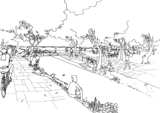
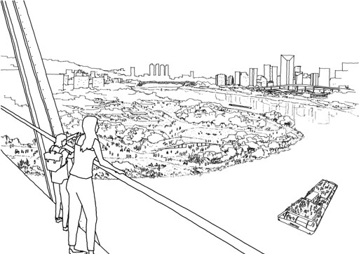
    TFUCP - Urban Fluvial Transportation of Public Cargo - Circuits: lacustrine touristic crossings

    AThroughout the Waterway Ring will be constructed twenty-four lacustrine touristic crossing. In those ports will dock urban passenger ships, touristic ships and ferries that are intended for crossing the dams.

    A-011A: TFUCC - Urban Fluvial Transportation of Commercial Cargo

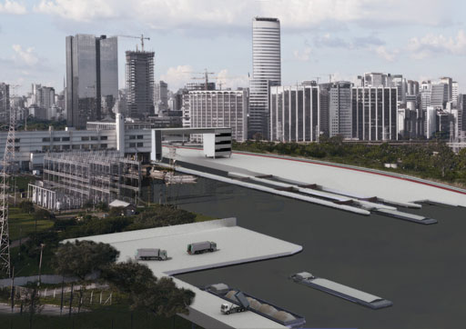
    TFUCC - Urban Fluvial Transportation of Commercial Cargo - Circuits: raw material for civil construction

    AAfter processing in Tri-ports, the waste converted into raw materials for industry and the aggregates for the construction industry will be forwarded for use in industry. Thus, it closes the cycle of reverse logistics, one of the principles of this project.

    A-011B: TFUCC - Urban Fluvial Transportation of Commercial Cargo

    TFUCC - Urban Fluvial Transportation of Commercial Cargo - Circuits: greengrocers

    The greengrocers’ products may be transported through waterway. In the ports near the greengrocers’ belt, the production will be transferred to boats and carried to various Eco-ports over the Waterway Ring. In these ports, the boats will dock at the pier in which will be set a market for the sale of those products.

    100

    A-101: Length 1A

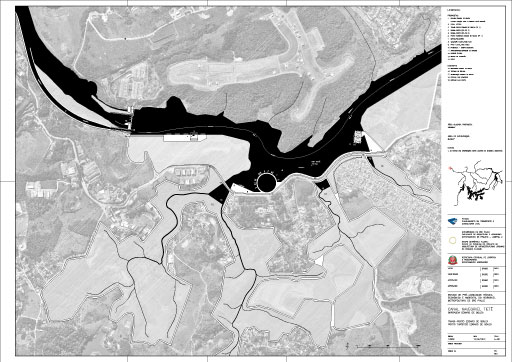
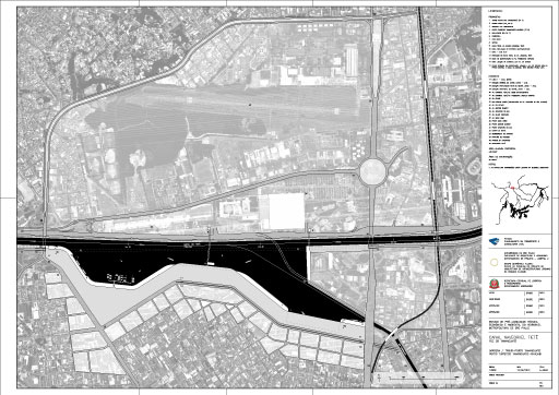
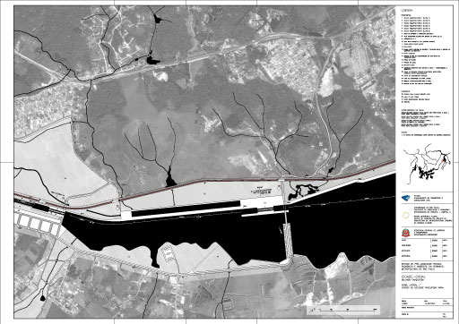
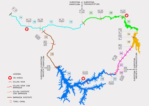
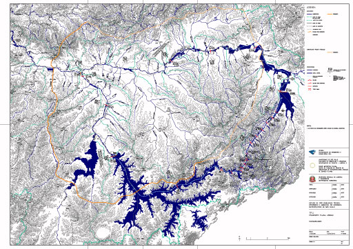
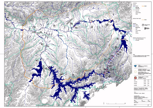
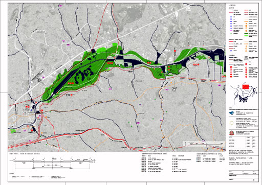
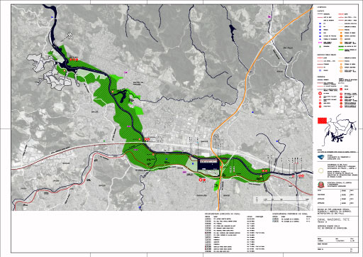
    Length 1A – Edgard de Souza dam > Carapicuíba stream Mouth

    The excerpt 2 of the Waterway Ring, in the Tietê River canal, is already navigable and has an extension of 41 km, from the upstream of Edgard de Souza dam in the municipality of Santana do Parnaíba, to downstream of the Penha dam. In this section it’s proposed the implementation of Carapicuíba Tri-port, the dock (water square) of the mouth of Tamanduateí River and the Trans-port of Aricanduva / Tiquatira / Cabuçu de Cima - which is consisted of three docks to the mouths of the rivers that nominate this complex.

    A-102: Length 1B

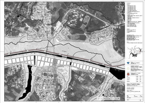
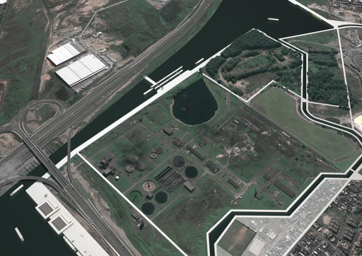
    Length 1B – Carapicuíba stream mouth > Cebolão moveable-dam/ lock

    The excerpt 1 of the Waterway Ring, in the Tietê River canal, is already navigable and has an extension of 41 km, from the upstream of Edgard de Souza dam in the municipality of Santana do Parnaíba, to downstream of the Penha dam. In this section it’s proposed the implementation of Carapicuíba Tri-port, the dock (water square) of the mouth of Tamanduateí River and the Trans-port of Aricanduva / Tiquatira / Cabuçu de Cima - which is consisted of three docks to the mouths of the rivers that nominate this complex.

    A-103: Length 1C

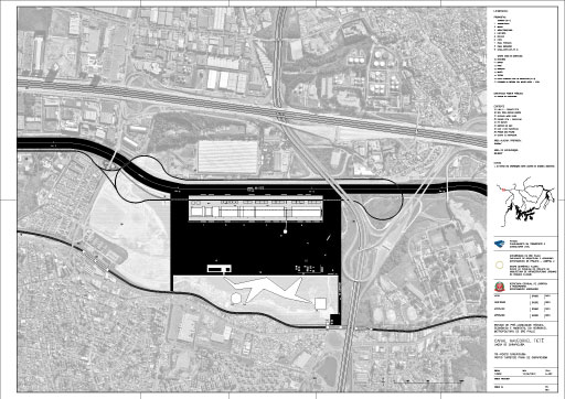
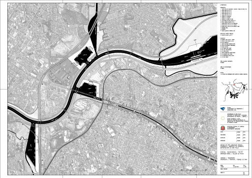
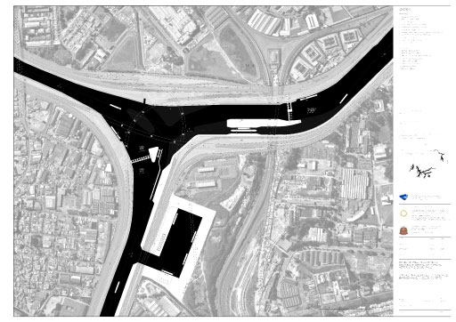
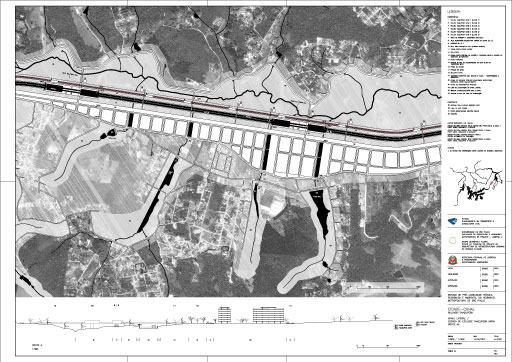
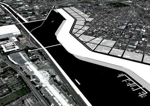
    Length 1C – Cebolão moveable-dam / lock > Tamanduateí mouth

    has an extension of 41 km, from the upstream of Edgard de Souza dam in the municipality of Santana do Parnaíba, to downstream of the Penha dam. In this section it’s proposed the implementation of Carapicuíba Tri-port, the dock (water square) of the mouth of Tamanduateí River and the Trans-port of Aricanduva / Tiquatira / Cabuçu de Cima - which is consisted of three docks to the mouths of the rivers that nominate this complex.

    A-104: Length 1D

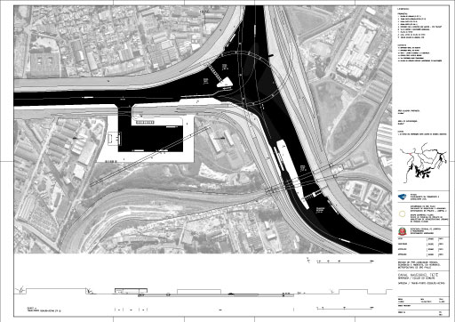
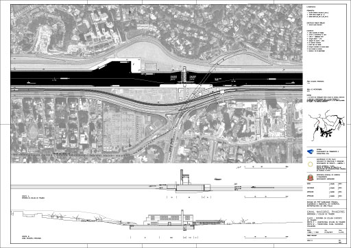
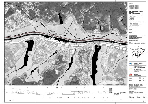
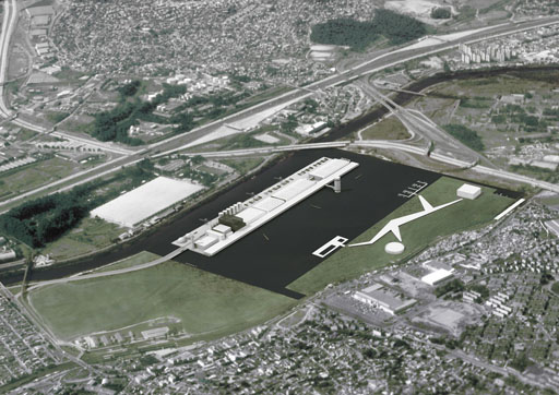
    Length 1D - Tamanduateí mouth> Penha Moveable-dam/ lock

    The excerpt 1 of the Waterway Ring, in the Tietê River canal, is already navigable and has an extension of 41 km, from the upstream of Edgard de Souza dam in the municipality of Santana do Parnaíba, to downstream of the Penha dam. In this section it’s proposed the implementation of Carapicuíba Tri-port, the dock (water square) of the mouth of Tamanduateí River and the Trans-port of Aricanduva / Tiquatira / Cabuçu de Cima - which is consisted of three docks to the mouths of the rivers that nominate this complex.

    A-105: Length 2A

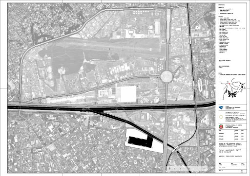
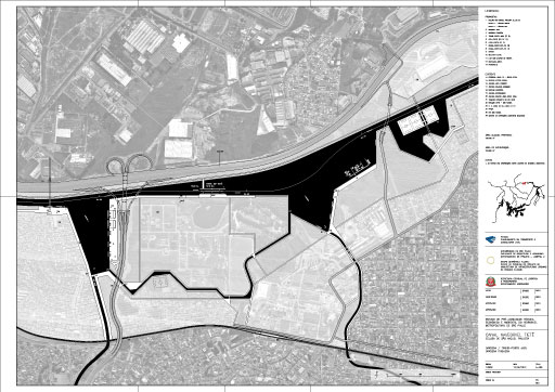
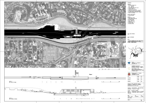
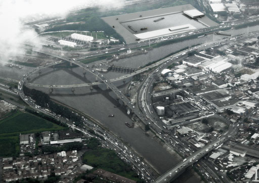
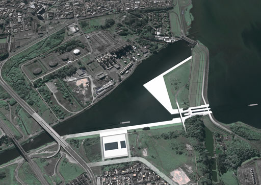
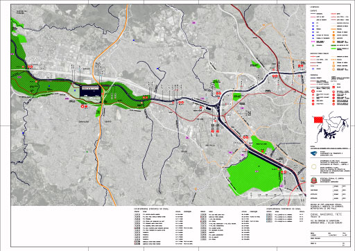
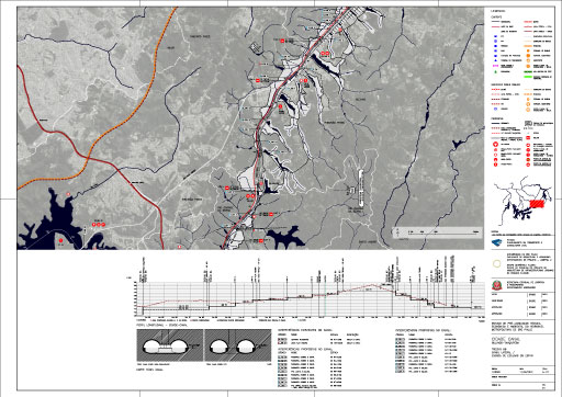
    A-105: Length 2A – Penha Moveable-dam / lock > São Miguel Paulista lock

    The excerpt 2 of the Waterway Ring, in Tietê River upstream of the Penha Dam to the mouth of the Taiaçupeba-Açu River is not navigable yet. Therefore are proposed three major lakes canals (Penha, São Miguel and Itaquaquecetuba) that will contribute to the macrodrainage and navigation in the Metropolis. In this excerpt, the proposed urban occupation should be stimulated by the construction of water squares, river boulevards, parks and harbors..

    A-106: Length 2B

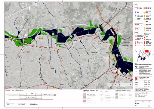
    Length 2B – São Miguel Paulista lock > Itaquaquecetuba lock

    The excerpt 2 of Hidroanel, in Tietê River upstream of the Penha Dam to the mouth of the Taiaçupeba-Açu River is not navigable yet. Therefore are proposed three major lakes channels (Penha, São Miguel and Itaquaquecetuba) that will contribute to the macrodrainage and navigation in the Metropolis. In this excerpt, the proposed urban occupation should be stimulated by the construction of water squares, river boulevards, parks and harbors.

    A-107: Length 2C

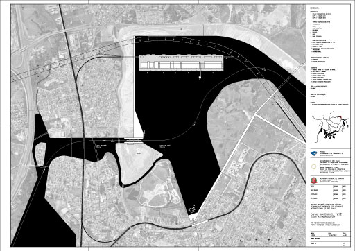
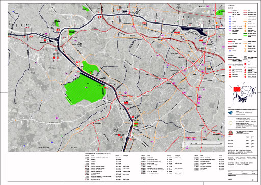
    Length 2C – Lock of Itaquequecetuba > Taiaçupeba-Açu mouth

    The excerpt 2 of Hidroanel, in Tietê River upstream of the Penha Dam to the mouth of the Taiaçupeba-Açu River is not navigable yet. Therefore are proposed three major lakes channels (Penha, São Miguel and Itaquaquecetuba) that will contribute to the macrodrainage and navigation in the Metropolis. In this excerpt, the proposed urban occupation should be stimulated by the construction of water squares, river boulevards, parks and harbors.

    A-109: Length 3A

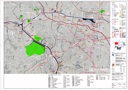
    Length 3A – Moveable-dam/ lock of Retiro > Dam / lock of Traição

    The excerpt 3 of Hidroanel is the channel of the Pinheiros River, upstream of the Retiro Dam to downstream of the Pedreira Dam. With 25 km long, the channel can be incorporated in a very short term to the waterway, linking the western zone, the cities of Barueri and Carapicuíba to the South Zone of the capital.

    A-110A: Length 3B

    Length 3B – Dam/ lock of Traição > Lateral Canal / Lock of Pedreira

    The excerpt 3 of Hidroanel is the channel of the Pinheiros River, upstream of the Retiro Dam to downstream of the Pedreira Dam. With 25 km long, the channel can be incorporated in a very short term to the waterway, linking the western zone, the cities of Barueri and Carapicuíba to the South Zone of the capital.

    A-110B: Length 3B

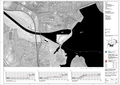
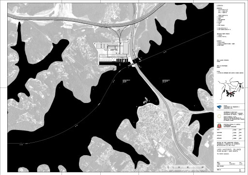
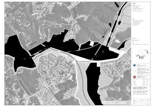
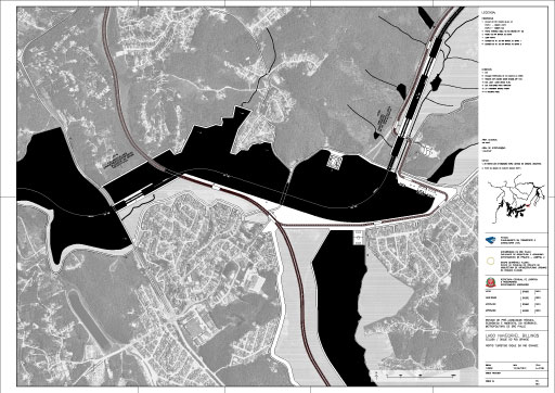
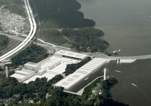
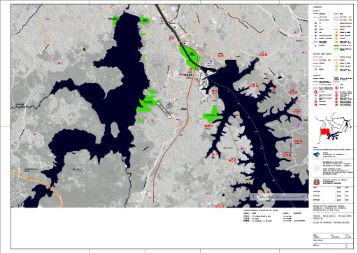
    Lenght 3B - Pedreira lock/ Billings reservoir

    The excerpt 3 of Hidroanel is the channel of the Pinheiros River, upstream of the Retiro Dam to downstream of the Pedreira Dam. With 25 km long, the channel can be incorporated in a very short term to the waterway, linking the western zone, the cities of Barueri and Carapicuíba to the South Zone of the capital.

    A-111: Length 4A

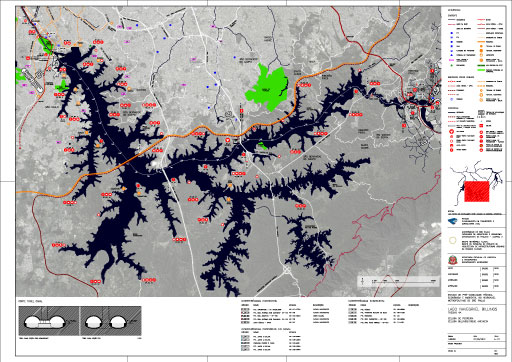
    Length 4A – Lateral Canal / Pedreira lock > Billings lock/ Dike of Anchieta

    The excerpt 4 of Hidroanel, the Billings Dam, is a particular component of the water transport circuit, due to its navigable condition and use as a source of water for the water supply. The dam is divided into two sections: the compartment Billings, from downstream of the Pedreira Dam to the Dike of Anchieta, and the compartment Rio Grande, from the Dike of Anchieta to the mouth of the Ribeirão da Estiva River, in Rio Grande da Serra.

    A-112: Length 4B

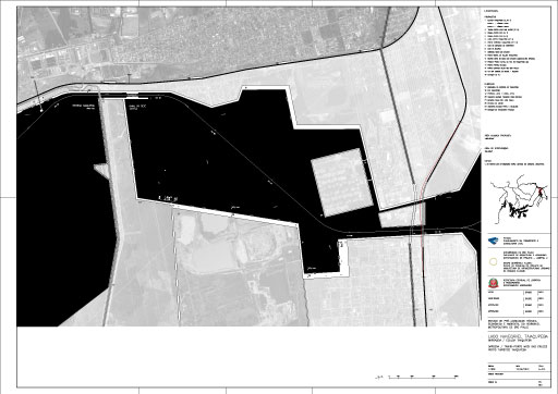
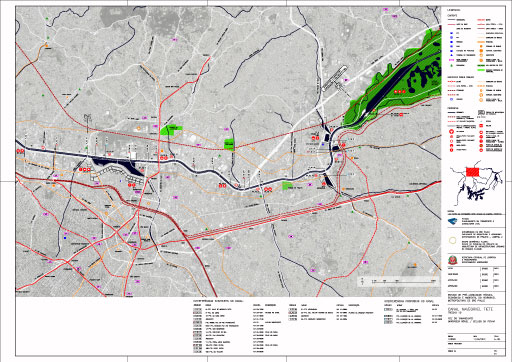
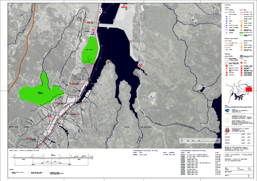
    Length 4B – Billings lock / Dike of Anchieta> Rio Grande lock / Dike of Rio Grande

    The excerpt 4 of Hidroanel, the Billings Dam, is a particular component of the water transport circuit, due to its navigable condition and use as a source of water for the water supply. The dam is divided into two sections: the compartment Billings, from downstream of the Pedreira Dam to the Dike of Anchieta, and the compartment Rio Grande, from the Dike of Anchieta to the mouth of the Ribeirão da Estiva River, in Rio Grande da Serra. Serra.

    A-113: Length 4C

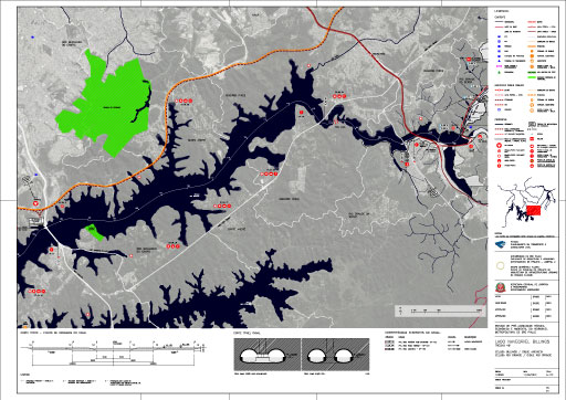
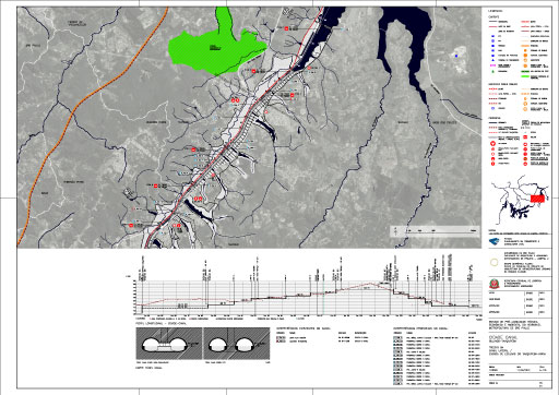
    Length 4C – Rio Grande lock / Dike of Rio Grande > Mouth of Estiva

    The excerpt 4 of Hidroanel, the Billings Dam, is a particular component of the water transport circuit, due to its navigable condition and use as a source of water for the water supply. The dam is divided into two sections: the compartment Billings, from downstream of the Pedreira Dam to the Dike of Anchieta, and the compartment Rio Grande, from the Dike of Anchieta to the mouth of the Ribeirão da Estiva River, in Rio Grande da Serra.

    A-114: Length 5A

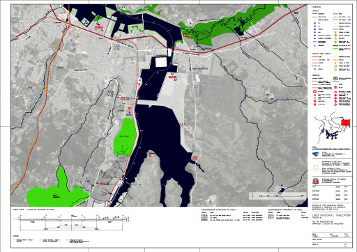
    Length 5A – Mouth of Taiaçupeba Açu > Dam / Lock of Taiaçupeba

    The excerpt 5 of Hidroanel is Taiaçupeba channel and navigable lake, from the mouth of the Taiaçupeba Açu River to the mouth of Taiaçupeba Mirim River. The proposed design of this large lake is the result of joining existing minor flooding on the border between the cities of Mogi das Cruzes and Suzano..

    A-115: Length 5B

    Length 5B – Dam / lock of Taiaçupeba > Mouth of Taiaçupeba Mirim

    The excerpt 5 of Hidroanel is Taiaçupeba channel and navigable lake, from the mouth of the Taiaçupeba Açu River to the mouth of Taiaçupeba Mirim River. The proposed design of this large lake is the result of joining existing minor flooding on the border between the cities of Mogi das Cruzes and Suzano.

    A-116: Length 6A

    Length 6A – Lateral Canal / Taiaçupeba Mirim Staircase Lock

    The excerpt 6 of Hidroanel is called "Canal City" as it proposes a new front of urbanization structured by fairway. This lateral canal to Estiva and Taiaçupeba Mirim rivers will connect the Billings and Taiaçupeba dams. The range of City-Canal is located in four municipalities: Mogi das Cruzes, Suzano, Ribeirão Pires and Rio Grande da Serra.

    A-117: Length 6B

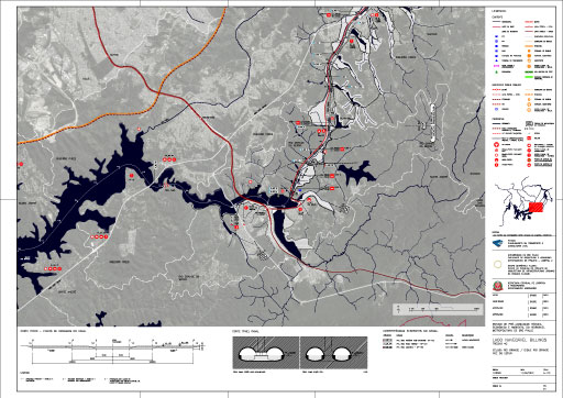
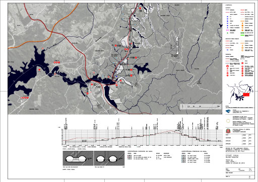
    Length 6B – Lateral Canal / Estiva Staircase Lock

    The excerpt 6 of Hidroanel is called "Canal City" as it proposes a new front of urbanization structured by fairway. This lateral canal to Estiva and Taiaçupeba Mirim rivers will connect the Billings and Taiaçupeba dams. The range of City-Canal is located in four municipalities: Mogi das Cruzes, Suzano, Ribeirão Pires and Rio Grande da Serra.

    A-118: Length 6C

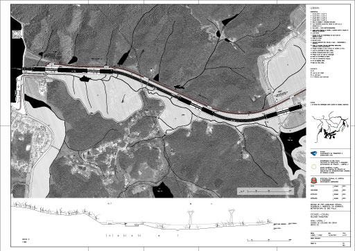
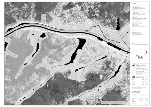
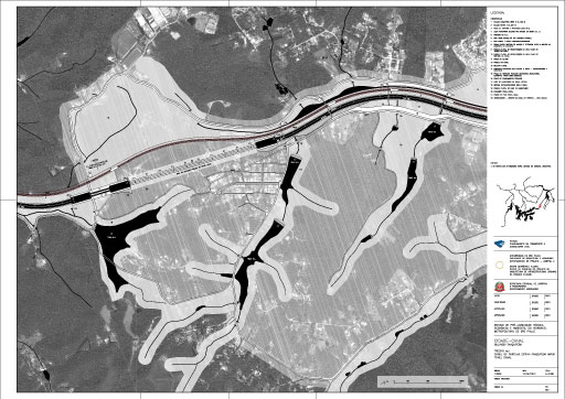
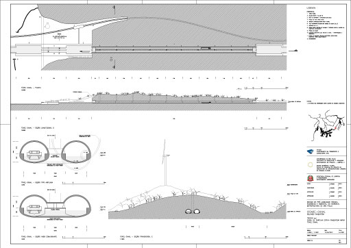
    Length 6C – Estiva - Taiacupeba Mirim watershed canal Estiva - Taiacupeba Mirim watershed canal

    The excerpt 6 of Hidroanel is called "Canal City" as it proposes a new front of urbanization structured by fairway. This lateral canal to Estiva and Taiaçupeba Mirim rivers will connect the Billings and Taiaçupeba dams. The range of City-Canal is located in four municipalities: Mogi das Cruzes, Suzano, Ribeirão Pires and Rio Grande da Serra.

    200

    A-201

    Edgard de Souza dam - Edgard de Souza Trans-port - Edgard de Souza Tourist Near the Edgard de Souza Dam is proposed a Trans-port, home port of unsorted garbage, dirt and debris. It also proposes a tourist harbor with marina / resort of circular shape. Outside this complex there is a large area for small boats that creates a large public bath in its interior. A set of floodplain parks (public parks with environmental quality) is further provided and in the future, a lateral canal to connect with the Tietê-Paraná Waterway

    A-202

    Carapicuíba Lagoon - Carapicuíba Tri-port - Carapicuíba beach Tourist - PortThe south area of the city of Barueri, on the border with Carapicuíba, is an industrial axis in the confluence of the waterway, railroad and highway, and therefore chosen to deploy the Carapicuíba Tri-port. The Tri-port building conforms as an island inserted into this pond which is bounded to the north by the Tietê River, and south by a proposed riverside park.

    A-203

    Dam / Lock of Cebolão - Dock / Cebolão-Retiro Trans-port - The excerpt along the highway system, known as “Cebolão” covers the mouth of the Pinheiros River and the Cebolão sluice (existing), which must be doubled to satisfy the demand of cargo flow planned. It is proposed a Trans-port which its construction includes: dock, administrative building and trans-board building. Sediments deposited at the encounter of the Pinheiros and Tietê rivers should be dredged constantly and the river islands should be suppressed.

    A-204A

    : Tamanduateí Mouth - Dock / Tamanduateí Trans-port - For implementation of the Tamanduateí Trans-port in a short term was chosen the next ground near the Tietê River with Tamanduateí River defined by the following routes: State Avenue, Rodolfo Miranda Street and David Brigio Street, in the low Bom Retiro. Today, part of the land is already used for the transport and management of solid waste and cargo. The project also provides the construction of a large square, with views of the State Avenue.

    A-204B

    : Tamanduateí Mouth - Dock / Tamanduateí Trans-port - In long term, close to Tamanduateí Trans-Port it is proposed the creation of a touristic circuit and an administrative esplanade for the Metropolitan Region. The edge of this esplanade will contain a pier that houses two Dredging-Port, a marina and an Eco-Port. The area is defined at East by the Armenia, Tietê and Carandiru Metro Stations, at North and West by Brás Leme Avenue, and at Southwest by Rudge Avenue and by Sérgio Tomás Street, and at the South by new lanes.

    A-205

    : Moveable-dam / lock of Penha – Aricanduva / Tiquatira / Cabuçu de Cima Trans-port - Cabuçu de Cima Trans-port is a complex distributed into three docks located at the mouth of the three rivers that give it its name. Upstream from ??this complex there is the dam of Penha, where the construction of a lock is foreseen. This transposition will allow navigation for another 14 km til São Miguel Paulista.

    A-206

    : São Miguel Paulista lock - Dock / Trans-port Jacu – Itaquera Dock - Itaquaquecetuba Tri-port follows the same principles of Carapicuíba Tri-port (A-202). A proposed road access with handles makes a direct connection from the port to the road ring. For rail access, a new branch must be designed, starting from the load line of the Federal Railway Network. To the reconfiguration of the area is proposed, near Itaquaquecetuba station, a park at a river island.

    A-207

    Itaquaquecetuba lock - Itaquaquecetuba Tri-port - Itaquaquecetuba Tourist Port - Itaquaquecetuba Tri-port follows the same principles of Carapicuíba Tri-port (A-202). A proposed road access with handles makes a direct connection from the port to the road ring. For rail access, a new branch must be designed, starting from the load line of the Federal Railway Network. To the reconfiguration of the area is proposed, near Itaquaquecetuba station, a park at a river island.

    A-209

    Dam / Retiro lockFor the connection of Pinheiros Canal with Tietê River is necessary to build the Retiro Lock, at Retiro Dam, near the mouth of Pinheiros River. So that it becomes navigable, this excerpt of the canal needs to be dredged, straightened and enlarged. The maintenance of the waterway through dredging must still remove the islands formed by the sediments accumulation that lies in the region. Finally, the vegetation riverbanks must be recovered..

    A-210A

    Dam / lock of Traição - Restoration of Existing Traição lock - Traição Lift Plant is located at Pinheiros River, near the Eng. Ary Torres Bridge, at São Paulo City. To enable the navigation of vessels of adequate size to the Waterway Ring, two projects were proposed. The first proposal is to expand the current length of the lock, so that it becomes 60m. Although it doesn’t meet the standard of the Waterway Ring locks, this reform can be implemented in a very short term, enabling navigation between Pedreira and Cebolão.

    A-210B

    Dam / lock of Traição - This second proposal for Traição Lock foresees the construction of a new lock on the east bank of the Pinheiros River, with two chambers of 9 x 60 meters, the standard dimension of locks of the Metropolitan Waterway Ring. For the construction of this lock will be necessary the compaction of the substation operated by CTEEP, and a study is required to investigate interference with SABESP pipelines. The proposed walkway in the basic design of the Pinnheiros Linear Park must be moved 250m to the south.

    A-211

    Dam / lock of Pedreira - Lateral Canal / lock of Pedreira - Port of lacustrine crossing Billings – Billings Eco-port - The transposition of the Pinheiros Canal to the Billings Dam should be taken by the Pedreira Dam’s lock. However, in one of the chambers of the current lock was installed pumping unit, and there are plans for another one. Thus, access to the Billings Reservoir will have to be done by a lateral canal with lock. Three possibilities of lock were studied, presented in this board by means of longitudinal profiles.

    A-212

    Billings lock / Dike of Anchieta –Anchieta Tri-port - The navigability of the excerpt connecting the two quotas of the Billings Reservoir depends on the construction of a lock and adaptation of the new bridge. In the same area is proposed the Anchieta Tri-port that will connect the plant to the Ring Road, to the industrial axis of Anchieta and to the future railway ring excerpt foreseen in the region. The design of the Tri-port takes advantage of local topography and is developed in two levels: a low pier for transhipment and sorting and processing system implemented at highest elevation.

    A-213A

    Lock / Dike of Rio Grande – Tourist Port dike of Rio Grande - The excerpt is located at the meeting of Canal-City Billings-Taiaçupeba with the Billings Plant in the municipality of Rio Grande da Serra . This connection is made through a mobile dam which keeps the area upstream at the elevation 746.50 , the area that is now silted up and must be dredged . In Rio Grande Dike, is necessary the execution of the lock of Rio Grande Dike ( E BIL 2 ) , which will allow waterway access to the City Canal. The area must have the rail handles upgraded.

    A-213B

    Lock / Dike of Rio Grande – Tourist Port dike of Rio Grande- the excerpt is located at the meeting of Canal-City Billings-Taiaçupeba with the Billings Plant in the municipality of Rio Grande da Serra . This connection is made through a mobile dam which keeps the area upstream at elevation 746.50 , the area that is now silted up and must be dredged . In Rio Grande Dike, is necessary the execution of the lock of Rio Grande Dike, which will allow waterway access to the City Canal. The area must have the rail handles upgraded.

    A-214

    Taiaçupeba Dam / lock Mogi das Cruzes Basin / Trans-port - Taiaçupeba Tourist PortThe excerpt covers the Taiaçupeba Plant connection with the proposed new lake : Navigable Lake Taiaçupeba Mouth , resulting of the joint of smaller existing floodings at the border between the cities of Suzano and Mogi das Cruzes. The Taiaçupeba Plant connection will be made by the existing dam. The area of the dike will be turned into a fluvial park-beach, equipped with a observation point looking over the reservoir, space of permanence and proximity to water.

    A-216A

    Lateral Canal / Taiaçupeba Mirim Staircase Lock- Taiaçupeba-Mirin - The lateral channel / staircase lock of Taiaçupeba Mirim River , northern stretch of the Taiaçupeba - Billings City - Channel, is located in the cities of Ribeirão Pires and Suzano and its layout follows the axis parallel to the rail branch Suzano -Rio Grande da Serra , at a distance of 37.5 meters from the axis of the railway in its eastern margin.

    A-216B

    Lateral Canal / Taiaçupeba Mirim Staircase Lock - The lateral channel / staircase lock of Taiaçupeba Mirim River begins at the elevation 748 m , near the mouth of the river in the city of Suzano and ends at an elevation of 773 m at the lock of sharing Estiva-Taiaçupeba Mirim , upstream of Itupeba , in Ribeirão Pires municipality.

    A-216C

    Lateral Canal / Taiaçupeba Mirim Staircase Lock - The lateral channel / staircase lock of Taiaçupeba Mirim River is 9900 meters long, 30 meters wide and 2.5 meters deep. To overcome the 25m of level difference, six locks are planned, dividing the navigation channel into five sections or five channels.

    A-216D

    Lateral Canal / Taiaçupeba Mirim Staircase Lock

    A-217

    Lateral Canal / Estiva Staircase Lock - The lateral channel / staircase lock of Estiva River, southern section of City Canal - Billings - Taiaçupeba , is located in Rio Grande da Serra and his path follows the parallel rail extension Suzano -Rio Grande da Serra axis. The lateral canal begins in Rio Grande compartment of Billings Dam and ends at the lock of sharing Estiva-Taiçupeba Mirim, at the border between Rio Grande da Serra and Ribeirão Pires . To overcome the 25.5 m of level difference, four locks are necessary ..

    A-218A

    Estiva - Taiacupeba Mirim watershed canal North Length - The Estiva-Taiaçupeba Mirim Sharing Canal is the canal that connects the basins of the two rivers which give it its name. Central segment of the City Canal - Billings - Taiaçupeba, the lateral canal is located at Ribeirão Pires City and has two settings : 3/4 in the open sky and 1/4 in tunnel . The sharing canal is 4330 meters long and is divided into two sections.

    A-218B

    Estiva - Taiacupeba Mirim watershed canal South Length – Tunnel-canal - The southern section of the Sharing, with 1180 meters in length, crosses the passage of Barro Branco - Ouro-Fino border of the municipalities of Rio Grande da Serra and Ribeirão Pires. This passage, in the watershed of the tributaries of the rivers Estiva and Taiaçupeba Mirim, consists of a tunnel-canal, with 1000 meters long .

    A-218C

    Estiva - Taiacupeba Mirim watershed canal – Tunnel-canal -- The tunnel - canal, proposed in the watershed of the basins of Estiva and Taiaçupeba Mirim rivers, consists of two ways with ten meters wide, 2.5 meters depth of water and maintenance dock with 1.5 meters width on both sides. Above the tunnel is proposed a windmill at the elevation 837 m - highest point of the Waterway Ring . The function of the windmill will be to produce power for pumping water into the sharing in canal in extreme situations of dryness , besides being a symbolic reference point from the top of the Waterway Ring.

    300

    A-302

    Carapicuíba Lagoon - Carapicuíba Tri-port - Carapicuíba Beach Touristic Port - The Carapicuiba Tri-port is situated in the center of the lagoon, configuring an island. The lighthouse, which connects to the building from a footbridge, characterizes the landscape. From the port, one can see the fluvial park with large scale buildings, shaping a civic center. Parallel to the park, lies the railway station Gen. Miguel Costa connected to the tourist port, and this one, connects to Metropolitan Waterway Ring through the piped Carapicuíba River.

    A-303

    Dam / Cebolão Lock - Dock / Cebolão-Retiro Trans-port - This is a view towards the Southeast, with the Tietê River in the forefront and in the left corner, the estuary of Pinheiros River. In the center we see the road complex known as Cebolão. Slightly above is the Cebolão Lock. In the upper right corner there is the Dock and Cebolão-Retiro Trans-port. The access is made under Castelo Branco highway and the left lane of avenue Marginal Rio Tietê.

    A-304

    Tamanduateí mouth - Dock / Tamanduateí Trans-port – Tamanduateí Touristic Port View of the mouth of Tamanduateí River, with touristic circuit and administrative esplanade of the Metropolitan Region

    A-306A

    São Miguel Paulista Lock - Dock / Jacu Trans-port - Itaquera Dock - At the center of the image, lies the São Miguel Paulista Lock , in the navigable Tietê Canal. In the lower left corner lies the São Miguel Paulista Dock and Jacu Trans-port. The natural course of the Tietê River connects the square to the water Itaquera Dock. In the center, the São Miguel Sewage Treatment Plant.

    A-306B

    Dock / Jacu Trans-port / Fluvial ports - In the forefront one sees the Jacu Stream. Throughout this canal extends a new boulevard that connects the urban fabric with the waterways. Paths for pedestrians and cyclists in the fluvial boulevards are continuous. The water is established as structuring and integrating element of the urban fabric, and creates new living spaces, leisure and contemplation. Through the pedestrian walkway, one sees the Jacu Dock, and at the back, São Miguel Trans-port.

    A-307

    Itaquaquecetuba Lock - Itaquaquecetuba Tri-port - Itaquaquecetuba Touristic Port - In the forefront one sees the eastern section of the road ring and railway ring, still to be developed. At right, in the image, there is an extension of the railway ring entering the Tri-port on the Itaquaquecetuba Lagoon. Above you see the lock that bears the same name of the Lagoon . At the back, it is possible to see the encounter between the Variant Parateí of Central do Brasil Federal School and the Line 12 - Sapphire of CPTM network.

    A-309

    Mobile Dam / Retiro Lock -At the forefront one sees the railway bridge of Lines 9 - Emerald and 8 - Diamond CPTM. Under the bridge we see the Retiro Mobile Dam and the proposal for two lock chambers on Pinheiros navigable Canal. To the upstream it is possible to see an Urban Cargo Boat (BUC) and a fixed floating dredge. In the background one can see the industrial zone of Vila Leopoldina.

    A-310

    Dam / Traição Lock - At the forefront lies the Traição Trans-port, on Pinheiros navigable Canal. Behind Power Sub-Station EMAE one sees the Traição Powerhouse. The two chambers of the Lock are located on the left bank of the river, near the bike path of the Module 4 of Pinheiros Linear Park and the Line 9 - Emerald of CPTM network. In the background, the buildings of the commercial complex Vila Olimpia.

    A-311

    Dam / Pedreira Lock - Lateral Canal / Pedreira Dam - lacustrine crossing Port - In the image one can see the widening of the Pinheiros Canal near Billings Reservoir. The connection of the two bodies of water is made through a side canal and lock, on the left shoulder of Pedreira Dam. On the west bank is designed the Pedreira’s Lock Urban Fluvial Park, which contains a balneary and makes the transition between the urban fabric and waterways infrastructure.

    A-312

    Billings Lock / Anchieta Dike - Anchieta Tri-port - To the right one can see the Billings Reservoir, on the region around the Anchieta Dike. In the center, the maneuver flooded square that leads to the ferry and screening sector of the Tri-port. The lighthouse marks the landscape and works as a point of reference in this great lake. Below the Anchieta Dike, there is the lock that allows navigation between the Billings compartment and Rio Grande compartiment. In the top left one can see the proposed route of the road ring and railway ring

    A-316A

    Lateral Canal / Taiaçupeba Mirim Staircase lock - The system of free public spaces configures a continuous network of urban fluvial parks that allows the route of pedestrians and cyclists in the Canal City. At the forefront lies the lock park. There is continuity in the path along the banks of the canal and between the park and the city. The bridges and fluvial boulevard make this continued transition. In the background one can see the residential buildings that shape the river boulevard.

    A-316B

    Lateral Canal / Taiaçupeba Mirim Staircase lock - The dense woodland designed along both banks of the canal preserves moisture in the fluvial environment and minimizes the loss of water of the canal by evaporation. The pedestrian and cycle paths of the river boulevard are terraces that overlook the view to the canal. The river boulevard is designed for the public promenade in the waterfront. The fluvial boulevard, shaped by the buildings in the background is visually and physically integrated into the fluvial environment of the fairway.

    A-316C

    Lateral Canal / Taiaçupeba Mirim Staircase lock - The lateral canal is understood as an organizing axis of urbanization. In the center, one of the locks of the staircase of locks or the Taiaçupeba Mirim River. The public facilities bridge-building connects the two banks, diminishing the distance between crossing routes for pedestrians and cyclists.

    A-320

    Pinheiros Navigable Canal - At the forefront lies the pedestrian walkway over Pinheiros Navigable Canal. Below there is a tourist passenger watercraft and in the background, a public load transport watercraft. The waterway of Pinheiros River relates harmoniously with Pinheiros Urban Fluvial Park.

2011 Articulação Arquitetônica e Urbanística dos Estudos de Pré-viabilidade do Hidroanel Metropolitano de São Paulo | Créditos